Sunday, December 26, 2004 at 00:58:53 UTC - Coordinated Universal Time.
Preliminary Earthquake Report
World Data Center for Seismology, Denver Colorado
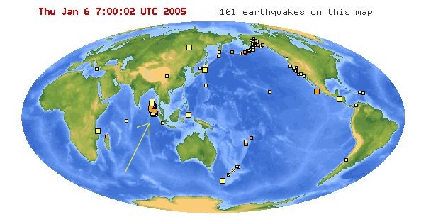
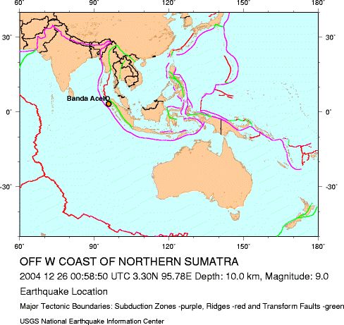
- 07:58:53 AM local time at epicenter
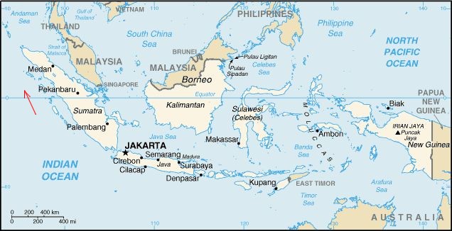
310 km (190 miles) W of Medan, Sumatra, Indonesia
1260 km (780 miles) SSW of BANGKOK, Thailand
1590 km (990 miles) NW of JAKARTA, Java, Indonesia
Parameters
Writtten on dec 28: At least 79,900 people were killed by the earthquake and tsunami in Indonesia. Tsunamis killed at least 41,000 people in Sri Lanka, 10,000 in India, 4,000 in Thailand, 120 in Somalia, 90 in Myanmar, 66 in Malaysia, 46 in Maldives, 10 in Tanzania, 2 in Bangladesh, 1 in Seychelles and 1 in Kenya.
The earthquake was felt (8) at Banda Aceh and Medan (5), Sumatra (2-4) and in parts of Bangladesh, India, Malaysia, Maldives, Myanmar, Singapore, Sri Lanka and Thailand. A mud volcano near Baratang, Andaman Islands began erupting on December 28.
The earthquake generated a large tsunami that caused widespread damage over countries bordering the Indian ocena, including Sri Lanka, India, Thailand Phuket,Malaysia, Andaman Islands, and Maldives.
As of jan 06 2005, more than 140000 lost their lives and millions were homeless. United Nations hosted a convention at Jakarta Indonesia on jan 6 to raise 1 billion US$ aid for the victims.
Tsunamis caused damage in Madagascar and Mauritius and also occurred on Cocos Island and Reunion. The tsunami crossed into the Pacific Ocean and was recorded in New Zealand and along the west coast of South and North America.
This is the fourth largest earthquake in the world since 1900 and is the largest since the 1964 Prince William Sound, Alaska earthquake.
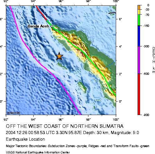
The devastating megathrust earthquake of December 26, 2004, occurred on the interface of the India and Burma plates  (see figure) and was caused by the release of stresses that develop as the India plate subducts beneath the overriding Burma plate. The India plate begins its descent into the mantle at the Sunda trench, which lies to the west of the earthquake's epicenter. The trench is the surface expression of the plate interface between the Australia and India plates, situated to the southwest of the trench, and the Burma and Sunda plates, situated to the northeast.
In the region of the earthquake, the India plate moves toward the northeast at a rate of about 6 cm/year relative to the Burma plate. This results in oblique convergence at the Sunda trench. The oblique motion is partitioned into thrust-faulting, which occurs on the plate-interface and which involves slip directed perpendicular to the trench, and strike-slip faulting, which occurs several hundred kilometers to the east of the trench and involves slip directed parallel to the trench. The December 26 earthquake occurred as the result of thrust-faulting.
Mid ocean rifts occur in central pacific region; from these ridges, plates start separating and molten magma flows towards east and west ending in subduction zones when colliding with the Asian and American continents.  . At the border mid ocean rift earthquakes occur as well as volcanic activity. The Atlantic ocean shows also the same events, with seismic activity and volcanoes occurring from
  North atlantic (Iceland) through St Helena and
  South Atlantic.
Preliminary locations of larger aftershocks following the megathrust earthquake show that approximately 1200 km of the plate boundary slipped as a result of the earthquake. By comparison with other large megathrust earthquakes, the width of the causative fault-rupture was likely over one-hundred km. From the size of the earthquake, it is likely that the average displacement on the fault plane was about fifteen meters. The sea floor overlying the thrust fault would have been uplifted by several meters as a result of the earthquake and this probably caused the large tsunami. The above estimates of fault dimensions and displacement will be refined in the near future as the result of detailed analyses of the earthquake waves.
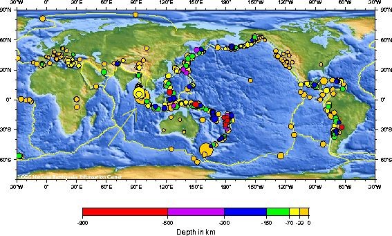
The world's largest recorded earthquakes have all been megathrust events, occurring where one tectonic plate subducts beneath another. See world plates.
These include:
- magnitude 9.5 1960
 Chile,
 - magnitude 9.2 1964 Prince William Sound, Alaska,
- magnitude 9.1 1957 Andreanov Islands, Alaska,
- magnitude 9.0 1952 Kamchatka.
 Chile,
 Alaska,
 Kamchatka.